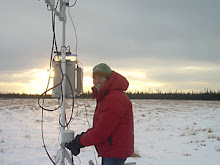
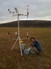
The meteorological tower (aka "met tower") is set up to hold the instruments that monitor weather, and will later hold the inlet for the instrument that measures N2O5. In order to completely understand the lifetimes and cycles of N2O5, we need to monitor air temperature and wind speeds. Temperature will affect the rate of chemical reactions happening in the air, while wind speeds and directions will dictate the source of our air flow.

The tower consists of two identical levels, each at different heights. In the photo above, each level holds a wind vane (black), cup anemometer (black), sonic anemometer (silver), and temperature probe (white cylinder). Sonic anemometers use sound waves to measure wind speeds in all three dimensions, while the cup anemometers catch the air like ice cream scoops and spin relative to wind speed.
 Typical nighttime wind flow at the Quist Farm site is from the northeast (~45 degrees). This typically occurs as a "drainage flow" from the city area of Fairbanks. Cold air is more dense than warm air, and will flow like water through terrain. The Quist Farm sits just downstream of Fairbanks in a valley. As cold air drains from the city at night it generates this general flow pattern. The above graph was made using the cup anemometer and wind vane data from the upper wind vane. It shows drainage flow on the night of 10/21/09. Keep in mind we use UTC standard time, so everything is synchronized. Therefore, 6AM on Oct. 22 (UTC standard) corresponds to 10PM on Oct. 21 (AK daylight).